REMOTE SETTING OUT ENGINEER
Advantages
- Design Layouts on site with your pinpoint accurate position on them
- Errors/mistakes can be relaised and fixed immediately by taking action in time
- TILT Sensor ensures that pole's verticality does not matter, you cannot go wrong
PRINCIPALS
- Daily checks (position, level)
- Reduce the need for surveys.
- Initial setting out for welfare
- You have engineer available for you via phone during the whole rent period
- Site Engineers available for surveys and Setting Out
SUBCONTRACTORS
- Terrain formation, Foundation, piling, pilecaps, drainage
- Cost of remediation work significantly reduced
- Cost of Setting Out Engineer significantly reduced while you have support and cover in case of any question
What if…
- …you did not need to call a Setting Out Engineer every time you need something to be marked?
- …you could mark many things, anytime you want, without keeping a full-time engineer on site?
- …you saw the drawings like never before? Along with your accurate position on them.
- …the foreman could mark most of the lines confidently to avoid having the expensive Setting Out Engineer on site?


CSI SouthEast delivers the above solution for you. You know everything, only call the engineer when it is inevitable and at the same time you pay significantly less compared to a full-time engineer.
We provide Leica Instruments fully prepared and optimised to your site for ease of using. Our experience and software park ensures that you cannot go wrong with it. We are also here to answer your questions not only regarding the equipment but as Site Engineers too.
Available equipment list
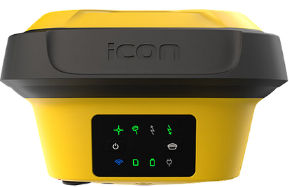
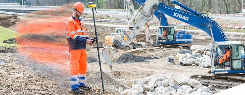
Leica iCON GPS 60 – Smart Antenna
Precise positioning on any construction site
The Leica iCON gps 60 GNSS Smart Antenna, working in combination with Leica iCONstruct field solution, is the perfect tool for any positioning tasks on any construction site. Featuring superior GNSS technology and integrated communication options, it enables you to carry out reliable positioning tasks on site much faster than before.
iCON gps 60 Smart Antenna delivers unmatched precision and performance in a rugged, compact unit that is designed to stand up to the harsh conditions typically found on construction sites.
We recommend this equipment for Terrain Formation.
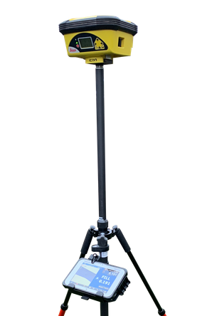
Leica iCON GPS 70T – Smart Antenna
Ultimate GNSS Rover and field solution for maximum efficiency. Speed up – anytime, anywhere.
Leica Geosystems introduces the most efficient construction GNSS rovers, the Leica iCON GPS 70 Series. Combining the latest GNSS technology and inertial measurement unit (IMU), the Leica iCON GPS 70 T is equipped with permanent tilt compensation and as well resistant to any magnetic interferences. Being calibration-free, the iCON GPS 70 T is ready when you are – anytime, anywhere. The iCON GPS 70 T releases the limitations of working with the pole in vertical positions and increases the productivity compared to conventional methods.
This GPS Antenna is paired with the CC80 controller. By eliminating all the possibilities of any wrongdoing, the kit available to be used for any offered purposes.
This rover practically covers all types of jobs. Our most reliable instrument in range.
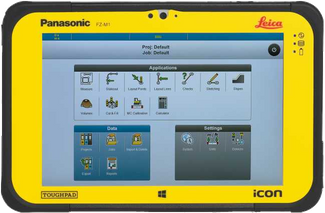
Leica iCON CC80 Controller
The Leica iCON CC80 is a thin, lightweight and rugged 7” Windows® tablet computer for all construction workers. It has a modern user interface with multi-touch technology.
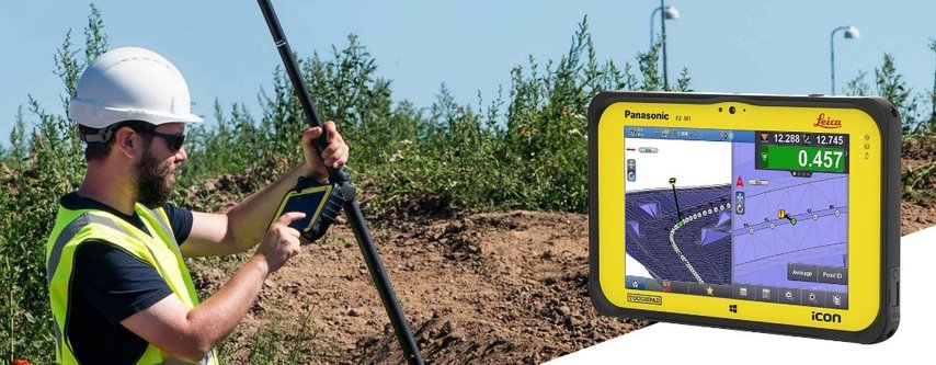
The iCON CC80 delivers with:
- Large 7” sunlight readable multi-touchscreen for convenient operation
- Microsoft Windows® 10 operating system
- Fully rugged design for use in toughest conditions (MIL-STD-810G, IP65)
- Long life battery pack (up to 16 hours)
The controller arrives with TeamViewer remote access preinstalled which makes us available to log in to the controller and update or upload drawings whenever necessary.
This controller comes with both GPS Antenna models. Bright, powerful, lightweight tablet to be there for you during the whole day. Easy to use, easy to understand.
FREQUENTLY ASKED QUESTIONS
- What is this service?
- Where is this service available?
- Why is this good for me?
- Why is it better than a full-time engineer?
- What education do I have to have to use it?
- What do I get for my money?
- What type of jobs is it good for?
- What accuracy can I achieve?
- How is this accurate on my site?
- How do I manage the drawings?
- How is this “failsafe”?
- What if I’m stuck? Is there any support? How?
- What if I need to be more accurate?
- What if I have design query? I used to ask the Engineer
What is this service?
By this service you are provided with a fully prepared GPS Equipment with continuous support so you can do most of the Setting Out on your own without hiring a Full-Time Setting Out Engineer on your site.
This option can be an ideal replacement of permanent Setting Out Engineer at the following tasks:
- Terrain formation
- Piling mat
- Piling
- Pilecaps, Groundbeams
- Strip foundation
- Manholes
- Drainage runs
- Pop-ups
- Kerb lines
- Landscaping
Where is this service available?
Wherever you have GPS Signal (practically the whole UK is covered) you can harvest its benefits. There are objects, however, like large trees, high buildings around which can significantly reduce the power of the signal from satellites. Before we start working on your job, we will check the area on Google Earth and might ask you to send us some pictures about the actual site. In case we cannot decide whether this service could work for sure on your site we investigate further and only offer this for you when we are sure that it works. CSI SouthEast Ltd is based in Wokingham, Berkshire. On distant sites, mileage might apply for the delivery, setup and training.
Why is this good for me?
By hiring our equipment you can reduce the need for Site Engineer presence significantly on your site and still having access to our expert Site Engineer colleagues in case of any query. That means lower cost without sacrificing anything, especially the access to the accurate positions of proposed objects on site.
Why is it better than a full-time engineer?
The Setting Out Engineer is the link between the design layouts and the real world. Their instruments and knowledge make them capable to give you the lines/point you need from the drawings.
Having a highly educated person on site is always expensive, not to mention that you depend on someone, their availability. You cannot work until they provide the information on site you need. Most of the time, especially at the beginning of the construction project you need only rough information, i.e. building outline, car park area for the welfare unit, piling mat, etc. where accuracy is not necessarily crucial. You still need to hire someone with the ability of a couple of mm accuracy because there has not been any other option so far.
CSI SouthEast has been working on many construction sites in the past years and kept working on giving the ability to their partners to work confidently even without our presence. We worked out the safest way for you to have access to everything you need immediately, without waiting time.
What education do I have to have to use it?
No worries. We have built up a system in the past years so we can do the hard work for you. No special education necessary to use this service.
Your Foreman can grab the kit and start working immediately with it after a short training.
What do I get for my money?
The service is added together by two parts.
HARDWARE (delivered to your site, setup and training):
- GPS antenna (Leica iCG60 or iCG70T by your choice)
- Leica CC80 Controller with mobile SIM card for the RTK and remote access
- Antenna Pole
- Bipod (if necessary)
SUPPORT SERVICES (ongoing):
- Drawing alignment, revision changes
- Producing Setting Out files by request
- Generating 3D models
- Remote help via phone by expert Site Engineers
What type of jobs is it good for?
Generally speaking, it’s good for any job conducted under the clear sky, where GPS signals can be received. It can be the most beneficial for Groundworker and Landscaping companies but, thanks to its accuracy, it can be used even by RC Frame contractors.
During the past years, we realised that the most difficult thing is to be confident on a site where there is nothing yet. There is no line to relate the building to, etc. Using this service means that you can be confident day by day, you can get familiar with the site faster than ever before. We also provide ‘anchors’ where you can go back anytime and check them whenever you are in doubt. We are also here for you in case you have a question. We can log in, see the screen you see and show you through the answer.
What accuracy can I achieve?
Accuracy depends on many things.
- DRAWINGS
- We position the drawings with less than 10mm accuracy. 10mm in the reality, not on the scaled drawing. We can place any scaled drawing for you. The placed drawings are as accurate as of the original design layout.
- GPS ANTENNA
- The GPS antenna is provided with unlimited Leica Smartnet correction. This typically allows you to have ~8mm accuracy horizontally and ~15mm vertically. The controller always shows you what accuracy you have at the given moment and will not let you save points easily with Low GPS Signal quality.
- GPS ANTENNA TYPE (We provide two types of antennas. One without or the other with TILT Sensor.)
- The TILT Sensor monitors the angle of the pole and adjusts the coordinates by removing the error caused by the pole being not held vertically.
- Without TILT sensor there is a chance to build in errors by not holding the pole vertically.
When we know the task you need this service for, we advise you what type of antenna would be ideal for the job. Also, by having the drawings we can tell you if there is anything wrong with them so you would know the achievable accuracy before you start using the kit.
How is this accurate on my site?
Every site starts with our Engineers’ job. We come to your site and just like any other Engineer would do we cross-check many things by using Total Stations besides the GPS Antenna. Once we finished and would be ready to work as Setting Out Engineer we set the GPS Antenna up for you instead. From that moment on it shows you everything accurately on the site. We also check whether we would mark exactly the same points by Total Station than you by using the GPS Rover.
Once the Site is set up and the Rover is ready to go, we go through the training part with your appointed colleague(s). After this part is done they will know what and how they can use. Do not worry if you cannot memorise everything by the first run. Whenever you’re stuck, just give us a call and will help you through in minutes.
How do I manage the drawings?
Anytime you have a newer revision of any imported drawings or you need a new drawing to be available on the controller too, just give us a call and we will sort it out. It usually takes about an hour but we guarantee you to have the new revision on your controller within 24 hours.
How is this “failsafe”?
We did everything we could to minimise the risk of wrongdoing.
- Wherever accuracy is critical (less than 50mm horizontal accuracy) we will recommend the TILT sensor Antenna to be used
- You will have Ground stations left on each site. These points are highlighted on every drawing we give you to upload to the instrument, so you can always go back to these known points and check whether the Antenna is accurate.
- We do not just provide the equipment. You will have expert support whether you have a question regarding the instrument or the drawings themselves.
What if I’m stuck? Is there any support? How?
Despite we try to provide everything on the clearest way it’s inevitable to have questions during the process. The solution is delivered via the Internet.
The equipment you have is one of the latest one so we have many options.
- We can share our screen with you to help us during explaining anything
- We can log in remotely to your controller and see your screen while we are talking via phone
- We can upload data to your controller, make amendments if necessary.
99% of occasions the problem can be solved online. In case we cannot sort it out remotely, we will come to you and fix it within 48 hours.
You do not have to have any extra hardware/software. Everything is preinstalled and prepared on the kit you receive from us. You are never going to be left without help.
What if I need to be more accurate?
When you have to have more accurate Setting Out than the GPS antenna can provide, you can call us for an Engineer to do it for you.
We can come and conduct the Setting Out and As-Built Surveys.
What if I have design query? I used to ask the Engineer
CSI SouthEast is not an equipment-hiring company. We do not only provide you the kit, we are offering fully equivalet solution to replace the Setting Out Engineer so we are available for design queries too.
Give us a call and we can go through them with you. Having connected via Skype we can share our screen with you to see the same drawing and discuss about the problem just like we were standing next to each other and pointing our finger on the drawing.
Every job is different.
Get in touch with us to choose the best method and hardware for your job.
Did you know...
- All of our colleagues are Civil Engineers with Bachelor or master's degree and have years of experience
- Working with us means that you hire a team working for you instead of one Site Engineer
- The Setting Out Report of marking Column/Wall centre lines on reinforcement can also be used for checking the cover for the bars as it contains the level of the point we marked?
- The Setting Out Report is a perfect solution to follow the revision of the design was in use on the day of Setting Out?
- The Setting Out Proposal shows you the lines we can mark you straight away upon request
- CSI SouthEast Ltd owns several Leica Total Stations (Robotic and Non-Robotic) and GPS/GNSS Rover
- Our Instruments are calibrated and maintained regularly
- 99% of cases we can be on site in 24 hours from the phone call
- CSI SouthEast is fully covered with Public Liability and Professional Indemnity Insurance
© Copyright 2018. All Rights Reserved.